A downtown focus perimeter, with GTA enquiries
Homeharbor coordinates home services across Toronto and the GTA, with downtown condo cleaning and handyman work as specialties. The shaded perimeter below shows an approximate downtown focus—from the Bathurst side and Bloor corridor to the eastern downtown near the Don and the central waterfront. It is an orientation outline, not a surveyed boundary or automatic acceptance geofence.
Homes outside the shaded outline can still be considered within the GTA. Send the postal code, actual address, service and timing for confirmation. No landmark is a company office, dispatch point or customer property. The map does not establish a fixed travel-time or parking guarantee.
Service-area perimeter map
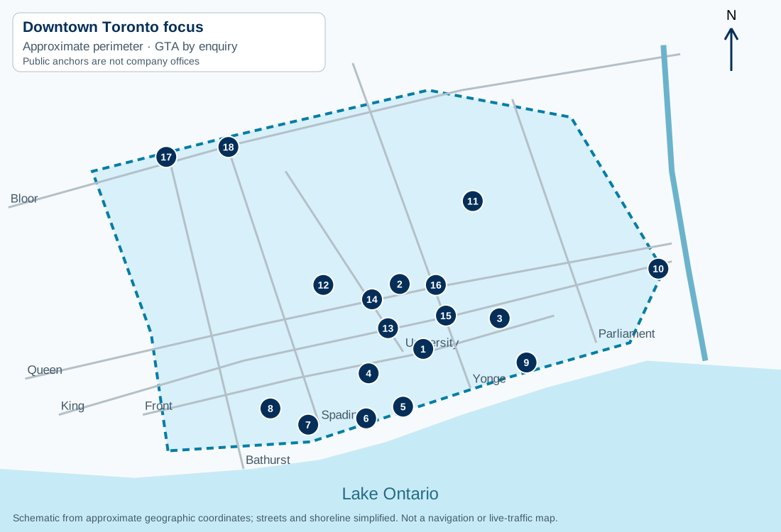
The ground anchors
| Map | Anchor & guide | Physical corridor | Approximate coordinates |
|---|---|---|---|
| 1 | Union Station & South Core | Front Street West between Bay and York | 43.6453, -79.3806 |
| 2 | City Hall & Nathan Phillips Square | Queen Street West and Bay Street | 43.6525, -79.3834 |
| 3 | St. Lawrence Market district | Front Street East and Jarvis Street | 43.6487, -79.3715 |
| 4 | CN Tower, Bremner & Railway Lands | Bremner Boulevard and Lower Simcoe Street | 43.6426, -79.3871 |
| 5 | Harbourfront & Queens Quay | Queens Quay West near Lower Simcoe Street | 43.6389, -79.383 |
| 6 | HTO Park & central waterfront west | Queens Quay West near Rees Street | 43.6376, -79.3874 |
| 7 | Music Garden & Spadina waterfront | Queens Quay West west of Spadina Avenue | 43.6369, -79.3943 |
| 8 | Canoe Landing & CityPlace | Fort York Boulevard near Dan Leckie Way | 43.6387, -79.3988 |
| 9 | Sugar Beach & East Bayfront | Queens Quay East and Dockside Drive | 43.6438, -79.3683 |
| 10 | Corktown Common & West Don Lands | Bayview Avenue and the West Don Lands | 43.6542, -79.3526 |
| 11 | Allan Gardens & Garden District | Gerrard Street East near Jarvis Street | 43.6617, -79.3747 |
| 12 | Grange Park, Grange & Chinatown | Grange Road south of Dundas Street West | 43.6524, -79.3925 |
| 13 | St Andrew & King–University | King Street West and University Avenue | 43.6476, -79.3848 |
| 14 | Osgoode & Queen–University | Queen Street West and University Avenue | 43.6508, -79.3867 |
| 15 | King station & King–Yonge | King Street and Yonge Street | 43.649, -79.3779 |
| 16 | Queen station & Queen–Yonge | Queen Street and Yonge Street | 43.6524, -79.3791 |
| 17 | Bathurst & Bloor corridor | Bathurst Street and Bloor Street West | 43.6666, -79.4112 |
| 18 | Spadina & Bloor corridor | Spadina Road and Bloor Street West | 43.6677, -79.4038 |
What changes when the location changes
Front Street and the rail corridor separate arrival routes around Union and the Railway Lands. Queens Quay identifies the waterfront but does not identify a building’s service entrance. Bathurst and Spadina continue far north of King and Queen; add the cross street. Eastern downtown around St. Lawrence Market and the West Don Lands needs a different approach from CityPlace or the western waterfront.
On the King Street transit-priority corridor between Bathurst and Jarvis, some through movements are restricted. Check the City’s current access guidance and current road restrictions. A loading space or public station entrance is not a parking permission for a service visit.
Confirm coverage with a useful request
Send the full postal code, nearest intersection, requested service, home type and preferred date. Describe the entrance, visitor registration, elevator requirements and legal loading or parking arrangement. For moving, include both addresses. The price depends on the actual work and access conditions; a postal code does not by itself appraise the job.
How postal-code coverage confirmation works · Prepare a booking request